Here is the link for the animation we watched in class today. I am sure that you all agree it was very powerful and is well worth of another viewing:
http://www.unep.org/wed/2006/english/Information_Material/WED2006_animation.swf
The wikipedia page for desertification highlights the causes, consequences and potential solutions very well.
http://en.wikipedia.org/wiki/Desertification
The world community is so concerned about the threat of desertification that it has set up a United Nations group to help combat it. Follow the links below to find out more:
Causes= http://www.unccd.int/publicinfo/factsheets/showFS.php?number=2
Consequences= http://www.unccd.int/publicinfo/factsheets/showFS.php?number=3
Other aspects of what the UN is doing can be viewed here:
http://www.unccd.int/publicinfo/factsheets/showFS.php?number=1
Showing posts with label The Hydrosphere. Show all posts
Showing posts with label The Hydrosphere. Show all posts
Wednesday, November 29, 2006

Monday, November 20, 2006
Flooding in the Horn of Africa
Sudan, Eritrea, Ethiopia, Somalia, Kenya, Uganda and Djibouti are the countries of the horn of Africa

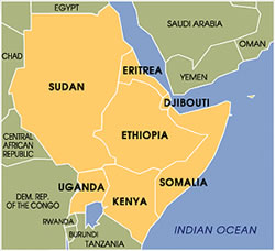
Usually this part of the world is famous for drought, famine and war but it has recently been hit by a devasting flood. Read the links below and look at the pictures to study the effects that the flood has had, how people have been killed by crocodiles and what has been done to help.
Water Supply Problems in LEDCs
This post will take you back a few weeks to when we studied the problems of water supply in Nepal. The link below tells how 5000 children a day die from drinking dirty water.
http://business.guardian.co.uk/story/0,,1944004,00.html
http://business.guardian.co.uk/story/0,,1944004,00.html
Thursday, November 16, 2006
Mississippi Floods of 1993
Hurricane Katrina proved that natural hazards can bring the most developed of nations to their knees and the Mississippi Floods of 1993 are another example of the raw power that water has.
http://www.weather.com/encyclopedia/flood/miss93.html
This Wikipedia article is excellent
http://en.wikipedia.org/wiki/Great_Flood_of_1993
Follow this link for some brilliant photos
http://mo.water.usgs.gov/Reports/1993-Flood/index.htm
http://www.weather.com/encyclopedia/flood/miss93.html
This Wikipedia article is excellent
http://en.wikipedia.org/wiki/Great_Flood_of_1993
Follow this link for some brilliant photos
http://mo.water.usgs.gov/Reports/1993-Flood/index.htm
Wednesday, November 08, 2006
Floods- Boscastle and Lynmouth
Tomorrow you will be study ing the Lynmouth flood of 1952 and comparing it with the Boscastle flood of 2004. Despite the floods being over 50 years apart you will be amazed by the similarites of the causes of these floods and the devasting effects that they had on two, small tourist villages in the south west of England.
Lynmouth
http://www.exmoor-nationalpark.gov.uk/the_lynmouth_floods_of_1952_exmoor
http://news.bbc.co.uk/onthisday/hi/dates/stories/august/16/newsid_2960000/2960180.stm
Boscastle
http://news.bbc.co.uk/1/hi/england/cornwall/3571844.stm
http://www.guardian.co.uk/weather/Story/0,,1284806,00.html
Comparison
http://www.geoprojects.co.uk/Keyfile/KeyBoscastle.htm
Lynmouth
http://www.exmoor-nationalpark.gov.uk/the_lynmouth_floods_of_1952_exmoor
http://news.bbc.co.uk/onthisday/hi/dates/stories/august/16/newsid_2960000/2960180.stm
Boscastle
http://news.bbc.co.uk/1/hi/england/cornwall/3571844.stm
http://www.guardian.co.uk/weather/Story/0,,1284806,00.html
Comparison
http://www.geoprojects.co.uk/Keyfile/KeyBoscastle.htm
Water - "Give a man a fish and he'll eat for a day, give him the means to fish and he'll eat for the rest of his life"
Some of you will know the above quote from the bible. Considering that the quote was written hundreds of years ago it is still very pertinent today.
It applies to our studies of water supplies in Nepal as if we give a family in Nepal a bucket of water, they can drink/wash for however long the bucket lasts them. If we give them the knowledge of how to find water, build a well, repair the well's pump and build a latrine then people in Nepal can drink/wash (with clean water) forever. Look at the Wateraid website below to see the difference that the scheme has made:
http://www.wateraid.org.uk/uk/learn_zone/educational_resources/777.asp
http://www.wateraid.org.uk/uk/learn_zone/games/pani/default.asp
http://www.wateraid.org/uk/learn_zone/video/5019.asp
It applies to our studies of water supplies in Nepal as if we give a family in Nepal a bucket of water, they can drink/wash for however long the bucket lasts them. If we give them the knowledge of how to find water, build a well, repair the well's pump and build a latrine then people in Nepal can drink/wash (with clean water) forever. Look at the Wateraid website below to see the difference that the scheme has made:
http://www.wateraid.org.uk/uk/learn_zone/educational_resources/777.asp
http://www.wateraid.org.uk/uk/learn_zone/games/pani/default.asp
http://www.wateraid.org/uk/learn_zone/video/5019.asp
Wednesday, November 01, 2006
Water in the UK
As you know from your lessons so far this week the UK has areas of the country with too much water, usually where there a few people, and areas of the country with a water shortage, usually where most people live. The links below show what the water companies and government are doing to try to make sure that areas with the highest demand for water actually get the supply they need:
Do you flush the toilet? Maybe you shouldn't! A silly story, but with the serious point that we can reduce demand to match the supply of water.
http://environment.guardian.co.uk/water/story/0,,1878947,00.html
Want to get out of washing up? Here is your excuse...
http://environment.guardian.co.uk/water/story/0,,1845323,00.html
A serious one. Thames Water want to build a huge new reservoir, just to meet rising demand in London.
http://environment.guardian.co.uk/water/story/0,,1872493,00.html
Also- there is a proposal to build a national grid for water, meaning that rivers and canals could be used to take water from the north and west of the UK to the south east where it is needed the most. This is a controversial issue. What do you think?
http://environment.guardian.co.uk/water/story/0,,1845355,00.html
You will notice that I got all of these resources from one website and they were all newspaper articles produced this year. It just shows how relevant this issue is to your lives.
Do you flush the toilet? Maybe you shouldn't! A silly story, but with the serious point that we can reduce demand to match the supply of water.
http://environment.guardian.co.uk/water/story/0,,1878947,00.html
Want to get out of washing up? Here is your excuse...
http://environment.guardian.co.uk/water/story/0,,1845323,00.html
A serious one. Thames Water want to build a huge new reservoir, just to meet rising demand in London.
http://environment.guardian.co.uk/water/story/0,,1872493,00.html
Also- there is a proposal to build a national grid for water, meaning that rivers and canals could be used to take water from the north and west of the UK to the south east where it is needed the most. This is a controversial issue. What do you think?
http://environment.guardian.co.uk/water/story/0,,1845355,00.html
You will notice that I got all of these resources from one website and they were all newspaper articles produced this year. It just shows how relevant this issue is to your lives.
Monday, October 30, 2006
Hydrographs
Hydrographs show how much water is in a river at any one point at any particular time. All hydrographs have a peak discharge, peak rainfall, lag time, rising limb and a falling (receeding) limb. Every river's hydrograph will be a different shape. The link below shows the main parts of a flood hydrograph:
http://www.bbc.co.uk/schools/gcsebitesize/geography/riverswater/floodingrev3.shtml
Obviously all drainage basins are different. Some are home to huge cities, whilst others are home to hills and forests. Some have permeable rock, some have impermeable rock. Some river's have many tributaries, others few. The point is that because of the geography of the drainage basin, some rivers are more likely to flood than others. This website help to explain why:
http://www.pupilvision.com/yeareleven/hydrograph.htm
http://www.bbc.co.uk/schools/gcsebitesize/geography/riverswater/floodingrev3.shtml
Obviously all drainage basins are different. Some are home to huge cities, whilst others are home to hills and forests. Some have permeable rock, some have impermeable rock. Some river's have many tributaries, others few. The point is that because of the geography of the drainage basin, some rivers are more likely to flood than others. This website help to explain why:
http://www.pupilvision.com/yeareleven/hydrograph.htm
Wednesday, October 11, 2006
Drainage Basins
Every single piece of land on the planet is part of a drainage basin. The largest drainage basin in the world is the Amazon, which covers an amazing one-third of South America (it is 6,144,727 km sq). Quite often drainage basins have been used as boundaries, for example the Hudson Bay Trading Company in North Canada was given the trading rights for the Hudson Bay drainage basin. This region later became known as the Northwest Territories of Canada. The River Congo drainage basin in central Africa has almost the same boundaries as the Democratic (?) Republic of Congo.
Anyway, follow the links and learn!
http://earthtrends.wri.org/maps_spatial/maps_detail_static.php?map_select=274&theme=2
http://en.wikipedia.org/wiki/Drainage_basin
The following link shows how a watershed follows the highest land.
http://www.sln.org.uk/geography/Documents/animations/Watershed2.ppt
Anyway, follow the links and learn!
http://earthtrends.wri.org/maps_spatial/maps_detail_static.php?map_select=274&theme=2
http://en.wikipedia.org/wiki/Drainage_basin
The following link shows how a watershed follows the highest land.
http://www.sln.org.uk/geography/Documents/animations/Watershed2.ppt
Monday, October 09, 2006
Why Study Water?
Some of you may wonder why studying water and its impact on the shape of the Earth and on people is important.
People think that one of the main conflicts of the 21st century will be over water. A professor of mine at University and my personal tutor (Dr Gwyn Rowley) was actually an advisor to the USA government over how the supply of water is one of the main causes of war in the area.
http://news.bbc.co.uk/2/hi/middle_east/2249599.stm
A huge amount of the world's population has no access to clean water, leading to disease and death.
http://whyfiles.org/131fresh_water/2.html
Obviously we get too much rain from time to time (we may get more due to global warming) and that causes floods which often leads to death and damage.
http://www.environment-agency.gov.uk/subjects/flood/?lang=_e
So in short, water determines whether we stay alive, how we grow food and how we clean ourselves. Too much water or a lack of it causes war, death and destruction for huge numbers of people every year. It is therefore an extremely important local and global issue for you to study.
People think that one of the main conflicts of the 21st century will be over water. A professor of mine at University and my personal tutor (Dr Gwyn Rowley) was actually an advisor to the USA government over how the supply of water is one of the main causes of war in the area.
http://news.bbc.co.uk/2/hi/middle_east/2249599.stm
A huge amount of the world's population has no access to clean water, leading to disease and death.
http://whyfiles.org/131fresh_water/2.html
Obviously we get too much rain from time to time (we may get more due to global warming) and that causes floods which often leads to death and damage.
http://www.environment-agency.gov.uk/subjects/flood/?lang=_e
So in short, water determines whether we stay alive, how we grow food and how we clean ourselves. Too much water or a lack of it causes war, death and destruction for huge numbers of people every year. It is therefore an extremely important local and global issue for you to study.
The Hydrological Cycle
The first lesson on the hydrosphere aims to teach you the inputs, outputs, stores and flows of the hydrological cycle. Put simply this is about how water gets into, leaves, is kept and moves around the ground.
This link shows you the key definitions of the hydrological cycle and has an excellent diagram showing you the various parts of the hydrological cycle.
http://www.sln.org.uk/geography/schools/blythebridge/gcseriversrevisionhc.htm
These links have animations (which I haven't yet figured out how to save to my computer so I can show you in class) that shows how water moves through the hydrological cycle.
http://ww2010.atmos.uiuc.edu/(Gh)/guides/mtr/hyd/smry.rxml
http://observe.arc.nasa.gov/nasa/earth/hydrocycle/hydro1.html
Finally for those of you who want to be able to talk like a 67 year old professor, here is the wikipedia link!
http://en.wikipedia.org/wiki/Water_cycle
This link shows you the key definitions of the hydrological cycle and has an excellent diagram showing you the various parts of the hydrological cycle.
http://www.sln.org.uk/geography/schools/blythebridge/gcseriversrevisionhc.htm
These links have animations (which I haven't yet figured out how to save to my computer so I can show you in class) that shows how water moves through the hydrological cycle.
http://ww2010.atmos.uiuc.edu/(Gh)/guides/mtr/hyd/smry.rxml
http://observe.arc.nasa.gov/nasa/earth/hydrocycle/hydro1.html
Finally for those of you who want to be able to talk like a 67 year old professor, here is the wikipedia link!
http://en.wikipedia.org/wiki/Water_cycle
Subscribe to:
Posts (Atom)