Here is the case study that you need to revise for next wednesday's lesson
http://www.divshare.com/download/1103723-6f5
Thursday, June 28, 2007
Tuesday, May 08, 2007
Housing Zones & Services in UK Cities
http://www.geographyatthemovies.co.uk/Settlement.html
Go to the above website and scroll down to Urban Land use. You can download an excellent movie showing the houses and services in different parts of cities.
Also if you remember the songs we played about services in different areas of the cities look at these videos:
http://www.youtube.com/watch?v=Rndv9wWIHQ4 This talks about the significance of the song and how it relates to the inner city. Very interesting.
http://www.youtube.com/watch?v=YHBKAyn17vw Penny Lane - you may recognise some of the places from your coursework.
Quality of Life and Standard of Living
You should all understand the difference between these now - quality of life is about how happy people are and the quality of things that they cannot buy such as education, and health care.
Standard of living is about money, average wage etc.
Standard of living is about money, average wage etc.
Tuesday, March 20, 2007
Pictures of Houses

Flats in the CBD. Look at the building work behind.

A row of houses in Smithdown Road A house in Calderstones Park
 A house in Calderstones Park
A house in Halewood - the edge of the city
Monday, March 19, 2007
www.upmystreet.com
The www.upmystreet.com website must have been created with this coursework in mind! It is a goldmine of information about local services and facilities that will influence the house price.
Go to the main page and enter the postcode of a place we visited in the Enter a Location box. It will take you to a screen with links on the left side to details about an areas schools, transport, crime rates, leisure facilties etc. These are all features that will affect the house price of an area but we did not study on the day - i.e. seecondary data.
Make sure you use this website.
Thursday, March 15, 2007
Statistics on the Areas we Visited
Each area we visited has a set of statistics which can tell you more about the quality of the houses, and thus, why they are worth a certain amount of money. The links below take you to a summary page showing the different types of statistics we study when looking at housing.
Liverpool CBD: http://neighbourhood.statistics.gov.uk/dissemination/LeadDatasetList.do?a=3&c=L3+4BX&g=358254&i=1001x1003&j=290885&m=1&p=1&q=1&enc=1&domainId=15
Smithdown Road: http://neighbourhood.statistics.gov.uk/dissemination/LeadDatasetList.do?a=3&c=L7+4LB&g=359471&i=1001x1003&j=291120&m=1&p=1&q=1&enc=1&domainId=15
Calderstones Park: http://neighbourhood.statistics.gov.uk/dissemination/LeadDatasetList.do?a=3&c=L18+3HZ&g=358627&i=1001x1003&j=290965&m=1&p=1&q=1&enc=1&domainId=15
Halewood: http://neighbourhood.statistics.gov.uk/dissemination/LeadDatasetList.do?a=3&c=L26+6LE&g=357807&i=1001x1003&j=290788&m=1&p=1&q=1&enc=1&domainId=15
The links take you to a page with a list of topics on. The statistics may be hard to understand but I recommend that you look at the 2nd topic down "2001 Census: Key Statistics". I suggest that you look at any set of data that could affect the value of the house. Explore it for yourself!
Tuesday, March 06, 2007
Map the area we visited
Use www.multimap.com to find the postcodes of the streets we did our survey in and you can piece together a map of our journey through Liverpool.
Postcodes for Houses
Here are the postcodes for the places we stopped the minibus at:
Liverpool CBD=L3 4BX or L3 4DA or L3 4DR
Smithdown Road= L7 4LA or L7 4LB
Calderstones Park= L18 3HZ or L18 6HS
Halewood= L26 6LE
You need to get 5 houses for sale in each of these postcodes if you can.
Liverpool CBD=L3 4BX or L3 4DA or L3 4DR
Smithdown Road= L7 4LA or L7 4LB
Calderstones Park= L18 3HZ or L18 6HS
Halewood= L26 6LE
You need to get 5 houses for sale in each of these postcodes if you can.
Liverpool Coursework
Sketch Map - for the many lazy students amongst you who woul dlike the computer to do your sketch map for you, here is an easy way.
Firstly save any photos you took with your digital camera or mobile phone onto your PC with an easily recognisable name.
Go to www.dumpr.net
In the bottom left corner there is picture of a bird with the phrase "turn your photos in to sketches" underneath. Click on this.
Where it says select your photo, look at the 4 tabs and click on upload.
Browse through the photos you saved and select the photo.
Click on Continue (in yellow writing in a blue box) underneath.
BINGO!
You can then annotate the photo with features that show a good/bad quality of life there.
Monday, February 05, 2007
Exam Answer Guide - Homework help
http://www.4shared.com/file/10115534/7639ddfd/GCSE_Exam_Answer_Guide.html
The above link will take you to the Geography GCSE exam answer guide. I created the exam answer guide to go with past paper questions you get for homework. It is vital that you spend 45 minutes to an hour completing every homework that you get, using the exam answer guide to model your answer. Click on the link, go halfway down the page, wait for around 5 seconds and you will see a underlined link saying download file underneath a URL box. Click the download file link, press open and the exam answer guide will be on your screen to save wherever suits you.
The above link will take you to the Geography GCSE exam answer guide. I created the exam answer guide to go with past paper questions you get for homework. It is vital that you spend 45 minutes to an hour completing every homework that you get, using the exam answer guide to model your answer. Click on the link, go halfway down the page, wait for around 5 seconds and you will see a underlined link saying download file underneath a URL box. Click the download file link, press open and the exam answer guide will be on your screen to save wherever suits you.
Spits


The above diagram and picture show how longshore drift has formed Spurn Head Spit on the Holderness Coast. The following website has an excellen animation to show the formation of a spit http://www.school-portal.co.uk/GroupDownloadFile.asp?file=21605
This website has a full panorama of the view aorund Spurn Head Spit http://www.panoramic-imaging.com/eastriding/spurn/spurnframe.htm
This website is for holidaymakers who regularly visit the spit and lists the activities they can do there http://www.totaltravel.co.uk/travel/north-england/yorkshire-wolds/spurn-head/guide/Spurn-Head
Longshore Drift

Longshore drift is the main process of transport of material on the coast. The diagram above shows how it works. Basically, waves approach the shore at an angle, taking the sand up the beach at that angle. When the wave goes out, the sand follows the backwash of the wave back to the sea in a straight line. The result is that sand particles have moved a short distance down the beach. Look at the following animation for more information http://www.school-portal.co.uk/GroupDownloadFile.asp?GroupId=12426&ResourceID=40403
Caves, Arches and Stacks

You may recognise the above photo as being the basis for the memory map we did about cave, arch and stack formation. Basically they form on headlands, where a weakness in the rock is eroded initially to form a cave. The cave gets eroded through to form an arch. Eventually the arch cannot support itself and collapses, leaving a stack. The stack gets undercut, developing a wave cut notch, that will cause the stack above it to collapse leaving a stump. The following website has an animation showing the process http://www.sln.org.uk/geography/Documents/animations/Stack%20formation.ppt#264,1,Cave Arch and Stack Formation
Headland and Bay Formation
 The above photo shows a headland with a bay behind it. Headlands and bays are formed when you get a column of hard rock alongside a column of soft rock. Obviously the softer rock erodes a lot faster than the hard rock. Where the column of soft rock is you get a bay (often with a beach) and where the column of hard rock is you get a headland. This link explains the idea in a lot more detail- http://www.georesources.co.uk/leld.htm
Cliff Formation

Cliffs form when you have one section of hard resistant rock running alongside the sea. Erosion takes place at the bottom of the cliff, forming a wave cut notch. The photo to the right is a classic example of a wave cut notch. You can clearly see where the erosion has taken place at the bottom of the cliff. Eventually the rock above the wave cut notch will collapse, leaving the whole process to start again!
Coastal Processes
Don't reinvent the wheel! Follow the link to the BBC Bitesize website for explanations, and animations, of coastal processes.
http://www.bbc.co.uk/schools/gcsebitesize/geography/coastal/coastalprocessesrev4.shtml
http://www.bbc.co.uk/schools/gcsebitesize/geography/coastal/coastalprocessesrev4.shtml
The Grand Canyon

Your presentation about the formation and uses of the Grand Canyon were wonderful. Most groups ended up teaching me something that I did not know, which is how it should be with independent research. The beautiful photo to the right, taken from www.geographyphotos.com which the school subscribes to shows the Grand Canyon at dawn. I think everyone will agree that it is a wonderful spectacle!
This link (http://www.nps.gov/grca/) is for the Grand Canyon National Park website. It will have loads of information about how the Grand Canyon is used, the threats that it currently faces and the solutions to the problems.
http://www.kaibab.org/geology/gc_geol.htm is a good website for information about how the Grand Canyon was formed.
???Rivers Task???
Can you explain why the features a river creates change as move from the upper to middle to lower courses?
Lower Course Features - Deltas, Levees and Floodplains

The lower course of a river is when its energy levels are low. This is due to the fact that the river is no longer flowing downhill at a steep angle. The lack of energy causes deposition to take place.
The above photo shows the delta of the Mississippi River in the USA. A delta is formed when a river meets the sea and the river deposits material faster than the sea can remove it. Thus many smaller channels are formed as the river winds its way around the material it has depsoited as it no longer has the energy to transport or erode it.
Middle Course Features - Meanders and Oxbow Lakes
This link (http://www.school-portal.co.uk/GroupDownloadFile.asp?file=21606) has an excellent explanation of how meanders and oxbow lakes are formed through erosion and deposition in the middle course of a river. Watch it and then go to the link for the BBC bitesize website which gives all of the detail you need about meander formation. http://www.bbc.co.uk/schools/gcsebitesize/geography/riverswater/riverfeaturesrev3.shtml
Upper Course Features of a River
 River features in the upper course include- waterfalls, rapids and interlocking spurs. The picture to the left shows the typical start to a river (www.geographyphotos.com). It is literally a place where water gathers together and begins to flow downhill. The erosion that takes place here is vertical. The excellent animation http://www.school-portal.co.uk/GroupDownloadFile.asp?file=55027&Groupid=12426 show a river's source.
The wonderful photo above shows a waterfall in the UK. Waterfalls form when you have a band of hard rock and soft rock, with vertical erosion. http://www.school-portal.co.uk/GroupDownloadFile.aspGroupId=12426&ResourceID=29560 is an excellent animation showing the process.
River Transport
River transport is obviously how a river moves the material it has eroded. Again, there are 4 types of transport. Can you remember them? If not, go to the excellent BBC Bitesize website link here to refresh your memory http://www.bbc.co.uk/schools/gcsebitesize/geography/riverswater/riverprocessesrev3.shtml
Look at the animation on the above website of how rivers transport material.
Look at the animation on the above website of how rivers transport material.
Erosion
Erosion is the wearing away of land as water flows over the bank or past the bed of a river. There are 4 processes of river erosion. Can you remember them? If not go to this link to remind yourself. The link also has an animation showing how the processes of erosion work.
http://www.bbc.co.uk/schools/gcsebitesize/geography/riverswater/riverprocessesrev2.shtml
http://www.bbc.co.uk/schools/gcsebitesize/geography/riverswater/riverprocessesrev2.shtml
River Processes
The following website is an excellent introduction to how rivers work. I used it with my AS class, so it may be a bit advanced but give it a try and feel free to email me any questions you have.
http://www.sciencecourseware.org/VirtualRiver/Files/page01a.html
http://www.sciencecourseware.org/VirtualRiver/Files/page01a.html
Welcome Back
Can I take this chance to apologise for the lack of updates to the blog over the last two months. I can blame technical problems, such as me forgetting the password to access the site, and also my laziness in not getting in contact with google to sort the issue out sooner.
Anyway, the blog will resume by giving a list of internet sites that go with each lesson you study in class, and seeing how much some of you got out of the Grand Canyon enquiry some additional research tasks which you can complete if you want to.
Please feel free to email me links to sites you find that are interesting and relevant to topics we have studied.
Wednesday, November 29, 2006
Desertification
Here is the link for the animation we watched in class today. I am sure that you all agree it was very powerful and is well worth of another viewing:
http://www.unep.org/wed/2006/english/Information_Material/WED2006_animation.swf
The wikipedia page for desertification highlights the causes, consequences and potential solutions very well.
http://en.wikipedia.org/wiki/Desertification
The world community is so concerned about the threat of desertification that it has set up a United Nations group to help combat it. Follow the links below to find out more:
Causes= http://www.unccd.int/publicinfo/factsheets/showFS.php?number=2
Consequences= http://www.unccd.int/publicinfo/factsheets/showFS.php?number=3
Other aspects of what the UN is doing can be viewed here:
http://www.unccd.int/publicinfo/factsheets/showFS.php?number=1
Monday, November 20, 2006
Flooding in the Horn of Africa
Sudan, Eritrea, Ethiopia, Somalia, Kenya, Uganda and Djibouti are the countries of the horn of Africa

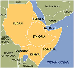
Usually this part of the world is famous for drought, famine and war but it has recently been hit by a devasting flood. Read the links below and look at the pictures to study the effects that the flood has had, how people have been killed by crocodiles and what has been done to help.
Water Supply Problems in LEDCs
This post will take you back a few weeks to when we studied the problems of water supply in Nepal. The link below tells how 5000 children a day die from drinking dirty water.
http://business.guardian.co.uk/story/0,,1944004,00.html
http://business.guardian.co.uk/story/0,,1944004,00.html
Thursday, November 16, 2006
Mississippi Floods of 1993
Hurricane Katrina proved that natural hazards can bring the most developed of nations to their knees and the Mississippi Floods of 1993 are another example of the raw power that water has.
http://www.weather.com/encyclopedia/flood/miss93.html
This Wikipedia article is excellent
http://en.wikipedia.org/wiki/Great_Flood_of_1993
Follow this link for some brilliant photos
http://mo.water.usgs.gov/Reports/1993-Flood/index.htm
http://www.weather.com/encyclopedia/flood/miss93.html
This Wikipedia article is excellent
http://en.wikipedia.org/wiki/Great_Flood_of_1993
Follow this link for some brilliant photos
http://mo.water.usgs.gov/Reports/1993-Flood/index.htm
Monday, November 13, 2006
Maps
Improve your knowledge of the world by playing the map games on the website below. I struggled with the Latin America amd Africa ones!
http://www.maps.com/FunFacts.aspx?nav=FF#
Enjoy!!!!
http://www.maps.com/FunFacts.aspx?nav=FF#
Enjoy!!!!
Wednesday, November 08, 2006
Floods- Boscastle and Lynmouth
Tomorrow you will be study ing the Lynmouth flood of 1952 and comparing it with the Boscastle flood of 2004. Despite the floods being over 50 years apart you will be amazed by the similarites of the causes of these floods and the devasting effects that they had on two, small tourist villages in the south west of England.
Lynmouth
http://www.exmoor-nationalpark.gov.uk/the_lynmouth_floods_of_1952_exmoor
http://news.bbc.co.uk/onthisday/hi/dates/stories/august/16/newsid_2960000/2960180.stm
Boscastle
http://news.bbc.co.uk/1/hi/england/cornwall/3571844.stm
http://www.guardian.co.uk/weather/Story/0,,1284806,00.html
Comparison
http://www.geoprojects.co.uk/Keyfile/KeyBoscastle.htm
Water - "Give a man a fish and he'll eat for a day, give him the means to fish and he'll eat for the rest of his life"
Some of you will know the above quote from the bible. Considering that the quote was written hundreds of years ago it is still very pertinent today.
It applies to our studies of water supplies in Nepal as if we give a family in Nepal a bucket of water, they can drink/wash for however long the bucket lasts them. If we give them the knowledge of how to find water, build a well, repair the well's pump and build a latrine then people in Nepal can drink/wash (with clean water) forever. Look at the Wateraid website below to see the difference that the scheme has made:
http://www.wateraid.org.uk/uk/learn_zone/educational_resources/777.asp
http://www.wateraid.org.uk/uk/learn_zone/games/pani/default.asp
http://www.wateraid.org/uk/learn_zone/video/5019.asp
Wednesday, November 01, 2006
Water in the UK
As you know from your lessons so far this week the UK has areas of the country with too much water, usually where there a few people, and areas of the country with a water shortage, usually where most people live. The links below show what the water companies and government are doing to try to make sure that areas with the highest demand for water actually get the supply they need:
Do you flush the toilet? Maybe you shouldn't! A silly story, but with the serious point that we can reduce demand to match the supply of water.
http://environment.guardian.co.uk/water/story/0,,1878947,00.html
Want to get out of washing up? Here is your excuse...
http://environment.guardian.co.uk/water/story/0,,1845323,00.html
A serious one. Thames Water want to build a huge new reservoir, just to meet rising demand in London.
http://environment.guardian.co.uk/water/story/0,,1872493,00.html
Also- there is a proposal to build a national grid for water, meaning that rivers and canals could be used to take water from the north and west of the UK to the south east where it is needed the most. This is a controversial issue. What do you think?
http://environment.guardian.co.uk/water/story/0,,1845355,00.html
You will notice that I got all of these resources from one website and they were all newspaper articles produced this year. It just shows how relevant this issue is to your lives.
Monday, October 30, 2006
Hydrographs
Hydrographs show how much water is in a river at any one point at any particular time. All hydrographs have a peak discharge, peak rainfall, lag time, rising limb and a falling (receeding) limb. Every river's hydrograph will be a different shape. The link below shows the main parts of a flood hydrograph:
http://www.bbc.co.uk/schools/gcsebitesize/geography/riverswater/floodingrev3.shtml
Obviously all drainage basins are different. Some are home to huge cities, whilst others are home to hills and forests. Some have permeable rock, some have impermeable rock. Some river's have many tributaries, others few. The point is that because of the geography of the drainage basin, some rivers are more likely to flood than others. This website help to explain why:
http://www.pupilvision.com/yeareleven/hydrograph.htm
Monday, October 16, 2006
Revision Books
The revision book that you need to purchase for Geography is the OCR (B) Geography book.
Tuesday 17th October
Due to the fact that half of the class will be missing from tomorrow's lesson as they are on the G&T activity day we will have a lesson off from the hydrosphere. The remainder of you will be able to finish your Iceland coursework and also work on your map skills.
Wednesday, October 11, 2006
Drainage Basins
Every single piece of land on the planet is part of a drainage basin. The largest drainage basin in the world is the Amazon, which covers an amazing one-third of South America (it is 6,144,727 km sq). Quite often drainage basins have been used as boundaries, for example the Hudson Bay Trading Company in North Canada was given the trading rights for the Hudson Bay drainage basin. This region later became known as the Northwest Territories of Canada. The River Congo drainage basin in central Africa has almost the same boundaries as the Democratic (?) Republic of Congo.
Anyway, follow the links and learn!
http://earthtrends.wri.org/maps_spatial/maps_detail_static.php?map_select=274&theme=2
http://en.wikipedia.org/wiki/Drainage_basin
The following link shows how a watershed follows the highest land.
http://www.sln.org.uk/geography/Documents/animations/Watershed2.ppt
Monday, October 09, 2006
Look at these
Today's pictures from the Guardian are brilliant.
http://www.guardian.co.uk/dayinpictures/page/0,,1891296,00.html
http://www.guardian.co.uk/dayinpictures/page/0,,1891296,00.html
Why Study Water?
Some of you may wonder why studying water and its impact on the shape of the Earth and on people is important.
People think that one of the main conflicts of the 21st century will be over water. A professor of mine at University and my personal tutor (Dr Gwyn Rowley) was actually an advisor to the USA government over how the supply of water is one of the main causes of war in the area.
http://news.bbc.co.uk/2/hi/middle_east/2249599.stm
A huge amount of the world's population has no access to clean water, leading to disease and death.
http://whyfiles.org/131fresh_water/2.html
Obviously we get too much rain from time to time (we may get more due to global warming) and that causes floods which often leads to death and damage.
http://www.environment-agency.gov.uk/subjects/flood/?lang=_e
So in short, water determines whether we stay alive, how we grow food and how we clean ourselves. Too much water or a lack of it causes war, death and destruction for huge numbers of people every year. It is therefore an extremely important local and global issue for you to study.
The Hydrological Cycle
The first lesson on the hydrosphere aims to teach you the inputs, outputs, stores and flows of the hydrological cycle. Put simply this is about how water gets into, leaves, is kept and moves around the ground.
This link shows you the key definitions of the hydrological cycle and has an excellent diagram showing you the various parts of the hydrological cycle.
http://www.sln.org.uk/geography/schools/blythebridge/gcseriversrevisionhc.htm
These links have animations (which I haven't yet figured out how to save to my computer so I can show you in class) that shows how water moves through the hydrological cycle.
http://ww2010.atmos.uiuc.edu/(Gh)/guides/mtr/hyd/smry.rxml
http://observe.arc.nasa.gov/nasa/earth/hydrocycle/hydro1.html
Finally for those of you who want to be able to talk like a 67 year old professor, here is the wikipedia link!
http://en.wikipedia.org/wiki/Water_cycle
Thursday, October 05, 2006
More Pictures
If you look at these pictures regularly, you will see how much of life around the world is relevant to your GCSE Geography course. Enjoy these.
http://www.guardian.co.uk/dayinpictures/page/0,,1888430,00.html
http://www.guardian.co.uk/dayinpictures/page/0,,1888430,00.html
Wednesday, October 04, 2006
Pictures From Around the World
The Guardian newspaper publish a set of pictures every day summing up what has happened in the world in the last 24 hours. Follow this link:
http://www.guardian.co.uk/dayinpictures/page/0,,1887439,00.html
Access the Guardian's website at http://www.guardian.co.uk/ to look at the photos every day.
http://www.guardian.co.uk/dayinpictures/page/0,,1887439,00.html
Access the Guardian's website at http://www.guardian.co.uk/ to look at the photos every day.
Tuesday, September 26, 2006
Why you are studying this coursework
The idea for this coursework came from my visit to Iceland with the A level geography students back in April.
Our guide for the trip was a man called Einar, who is an exceptionally passionate environmentalist and a tour guide to earn a bit of money. As usual the tour guide and teachers sat at the front of the coach and Einar was talking to me about his work fighting the construction of a dam in east Iceland. He showed me magazine articles in which he highlighted the hugely negative impact that the dam would have on the birds of Iceland. When I got home, I knew that I would have to organise a new piece of coursework for this year so I started researching the topic in more detail and we have ended up with this.
More information about Iceland can be found at:
The skills that you gain doing this coursework will be very useful for you at All Saints Sixth Form and University (and ultimately at work) as it teaches you to independently research and write an article giving different points of view and justifying an opinion.
Download Instructions
As some people have been saying that they cannot downlaod stuff from the website. Here is a guide for you to follow:
1. Click on the link that I have posted.
2. Clicking on the link will take you to a new page in the same window with the title of the file that you want to download in bold.
3. Scroll to the bottom of this page and there is a download button at the bottom of the page. Click the download button.
4. After you have clicked the download button a new window will appear. Again scroll down to the bottom of this page. There will be a 10 second countdown and then the download button will appear in black. Press the download button.
5. After pressing the download button a screen will appear asking if you want to open or save the file. Choose save, and save the file to your computer under a name that you will remember. The file is then yours to use forever.
No excuses now!
Monday, September 18, 2006
More Resources
Use this list of internet resources to complete additional research.
http://www.4shared.com/file/3829086/d0219400/internet_resources.html?
Use these quotes to add that authentic journalistic touch to your articles.
http://www.4shared.com/file/3829073/27d37c40/quotes.html?
Just in case you left your information booklet at school and think that you cannot do your homework - think again! Here is the booklet.
http://www.4shared.com/file/3829059/f530f7dc/arguments_for_and_against.html?
Finally, here is a copy of the mark scheme we will use to mark your coursework. Use it if you are unsure about what sort of information to put in or unsure about the writing style the newspaper should be constructed in.
http://www.4shared.com/file/3829075/ceb0d975/karahnjukar_iceland_mark_scheme.html?
Information for Iceland Coursework
You will get two weeks or 6 lessons of class time plus two week sof homework to complete your coursework. A good piece of work will make use of the resources we give you in class, an excellent piece of coursework will use the information here to add detail and independent understanding to the work.
Monday, September 11, 2006
Iceland Coursework Downloads
Here is the link for your Iceland coursework task in case you leave yours in school. Click on the link, scroll to the bottom of the page, wait for the countdown to finish and the download button to show, click the download button and save the file to your computer.
http://www.4shared.com/file/3650503/9b7bda86/cross_unit_task_iceland.html?
If you want to type your coursework instead of write it up, follow the link below and you can download the newspaper layout. Follow the instructions above.
http://www.4shared.com/file/3430979/ff7d0890/iceland_newspaper_outline.html?
Iceland Coursework Links
The Iceland coursework is worth 10% of your final GCSE mark and it takes the form of a newspaper article about the controversial Karahnjukar dam project in East Iceland.
The dam is a very controversial project in Iceland because of the environmental impact that the hydro-electric dam will have. Lower down in the school we have taught you that renewable energy is always good, however that is not always the case!
There are lots of websites that you can use to access opinions, maps, photos etc about the project. Follow the links below and use them to help you research the huge variety of opinions for your newspaper article. By all means make notes, get photos and pictures from the websites, but do not copy and paste stuff because I know what the articles say and I mark the work!
http://www.karahnjukar.is/EN/ positive maps, photos and public opinion
http://www.natturuvaktin.com/english.htm negative impact on wildlife
http://www.inca.is/newspageiv.asp?ID=16 negative letter to Alcoa president
http://www.agiweb.org/geotimes/aug02/WebExtra0801.html balanced review
http://www.inca.is/photosiv2.asp?flokkur=kara photos of land to be flooded
http://www.mindfully.org/Water/2004/Karahnjukar-Hydroelectric-Dam1jan04.htm negative
http://lmhwww.epfl.ch/Services/ReferenceList/2004_fichiers/karahnjukar/491karanhnjukarPhotos.htm photos and images
http://www.icelandinfocus.com/ general website
http://www.icelandinfocus.com/index.php?/article/positive_effects_of_the_karahnjukar_project/
http://www.icelandinfocus.com/index.php?/article/negative_effects_of_the_karahnjukar_project/
http://www.guardian.co.uk/conservation/story/0,,1094580,00.html balanced
http://forums.virtualfestivals.com/forums/lofiversion/index.php/t40067.html opinions
http://www.lv.is/files/2005_9_21_LV_environment_in_our_hands_2005.pdf positive info booklet about sustainable energy use. An excellent resource.
http://www.fwee.org/Tours.html about hydroelectric power
Saturday, September 02, 2006
Welcome
This is aimed at the pupils studying GCSE Geography at All Saints Catholic High School in Kirkby, but relevant to anyone studying the Avery Hill Geography GCSE specification. You are really lucky to have chosen Geography as a GCSE option.
You are studying about Planet Earth and how people and nature shape its people, cities, countryside, economy, environment, rivers, coasts, ecosystems, weather, climate, hydrosphere and lots lots more. It is a fascinating subject, a complex subject and the most relevant subject to help you understand the world of the past, present and future.
As we cannot teach you everything we would like to in class, the idea of this blog is to post links to websites that you can use to deepen your understanding of the topics taught in class. Posts will hopefully organised by topic. By choosing to study GCSE Geography you have already proved yourself to be an inquisitive, globally and locally aware person. Use this blog to help improve your grades by reading relevant internet sites, but also use it if you enjoy learning about Planet Earth for the sake of knowledge alone.
Subscribe to:
Comments (Atom)